Locating precise land records within the city limits of Canton, Ohio, serves as a foundational step in conducting proper real estate due diligence. As the county seat of Stark County, tracking Canton’s diverse property ownership, historical transfer values, and exact tax metrics requires deep interaction with county database systems. The primary structural repository for this data layer is the Stark County Auditor’s Office portal. This comprehensive guide details how to execute a targeted Canton property search, parse through digital property cards, and extract critical public valuation records.
The Crucial Administrative Role of the Stark County Auditor
In Ohio, public real estate tracking is split between municipal interest and county-wide administration. While properties are physically located within the City of Canton, the legislative authority to map, value, and track those parcels falls under the jurisdiction of the Stark County Auditor.
The Auditor serves as the chief fiscal officer and assessor for all parcels within Canton. To maintain accurate property records and ensure equitable taxation across different neighborhood zones, the Auditor’s office performs three core duties:
- The Valuation Cycle: The Auditor calculates the fair market worth of land and structures via a physical sexennial reappraisal every six years and a statistical triennial market update every three years.
- The Land Records Management: The Auditor’s map department continuously updates the municipal platform, processing parcel splits, tracking property transfers, and updating GIS layout boundaries.
- The Tax Duplicate Preparation: The Auditor multiplies a property’s taxable value against local, voter-approved millage levies (including the Canton City School District levies) to determine baseline real estate tax liabilities.
Understanding Key Public Property Indicators
Before executing an online query on the public database, you must familiarize yourself with standard Ohio property card variables. Interpreting these fields correctly allows you to assess a property’s legal status like a licensed title agent.
| Indicator Label | Technical Local Definition | Practical Value for Property Searches |
| Parcel Number (ID) | A structured string of digits containing routing and routing-sequence codes unique to a specific lot. | Eliminates search errors by pointing directly to one definitive plot of land regardless of name changes. |
| Millage Rate | The tax rate applied to a property’s assessed value, expressed in tenths of a cent per dollar of valuation. | Outlines the localized taxing burdens determined by individual Canton city wards and school districts. |
| Conveyance Data | The official legal log documenting the transfer of a property title between different entities. | Verifies the valid contract price, transfer timeline, and historical deed type of past market sales. |
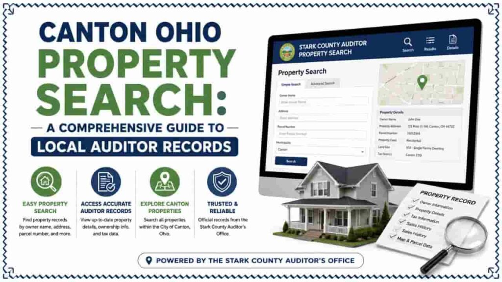
Step by Step: Conducting a Canton Property Search
The official Stark County Real Estate Search web portal is responsive and structured for public access. Follow this structured roadmap to look up any residential or commercial asset inside Canton city limits.
Step 1: Go to the Official Portal Interface
To protect your search data and guarantee authenticity, avoid using paid, third-party search scraper sites. Access the data directly through the official Stark County Real Estate Search system managed by the County Auditor.
Step 2: Inputting Search Parameters
The interface gives you multiple database query vectors. For properties inside Canton, utilize these specific formatting strategies:
[Stark County Search Portal Option Selection]
├── Search by Site Address ──► (Best for specific homes; use exact street numbers)
├── Search by Owner Name ──► (Format as: Last Name First Name)
└── Search by Parcel ID ──► (Best for complex commercial lots or vacant land)
1. By Site Address: Enter the street number and street name. Because database entries rely on standardized address indexing formats, omit punctuation. Type Tuscarawas St W instead of Tuscarawas St. W. If you are unsure of the spelling, type only the street number and the first few letters of the street name to trigger a selection list.
2. By Owner Name: Input the last name followed by a space and the first name (e.g., Smith Robert). For corporate real estate holdings or LLC investments common in downtown Canton, input the registered business name exactly as filed with the Ohio Secretary of State.
3. By Unique Parcel ID: If you know the multi-digit parcel ID number, type it into the input field without spaces or dashes. This directly bypasses potential address anomalies and opens the target property page instantly.
Analyzing the Auditor Property Card Structure
Once you select a property from the index results, the portal generates a multi-tabbed property profile. To extract actionable data, look closely at these foundational sections:
1. The Summary Matrix Tab
This area outlines the basic administrative parameters of the lot. Here, you will find the current legal owner’s name, the mailing address for tax statements, the legal land description (including lot numbers from the original Canton city subdivision plats), and the current neighborhood routing code.
2. The Value History Module
This module lists the historical evolution of the property’s financial value over previous evaluation cycles. It breaks the data down into separate columns for Land Value and Building Value.
Total Appraised Value = Land Appraised Value + Building Appraised Value
Reviewing this timeline shows you how much your property value changed during recent county updates. Remember, in Ohio, your actual real estate tax is calculated using the Assessed Taxable Value, which is exactly 35% of the total appraised value.
3. The Tax Tab and Levies Display
This screen shows the annual gross taxes, non-business credits, homestead reductions (if applicable), and special assessments (such as municipal street lighting or sweeping fees specific to Canton city ordinances). It details whether current-year tax obligations are fully paid or if there are outstanding, delinquent balances that could cause a county tax lien foreclosure.
Advanced Verification: GIS Mapping and Deed Matching
For deeper property evaluations, do not stop at textual records. Cross-reference the Auditor’s card data with secondary integrated county systems.
Activating the Stark County GIS Parcel Viewer
From the property summary page, select the map or interactive parcel viewer link. This action opens the official Stark County GIS system, displaying the physical geographic boundaries of the Canton parcel superimposed over high-resolution aerial imagery. This feature allows you to visually inspect building placements, estimate setbacks, check physical roadway access points, and verify if a structure lies inside a designated FEMA floodplain zone.
Cross-Referencing the County Recorder Index
While the Auditor tracks property values for tax purposes, the official legal transfer deeds are registered at the Stark County Recorder’s Office. If a property search indicates a recent sale, copy the recorded Deed Book/Page number or Instrument ID from the Auditor’s sales tab. Inputting that specific identifier into the Recorder’s record database allows you to view the scanned copy of the original signed deed to check for specialized easements, rights-of-way, or restrictive covenants.
Troubleshooting Common Property Search Problems
- The Address Returns No Results: If a search for a downtown Canton location fails, the property might be indexed under a different structural classification (such as an administrative multi-parcel unit). Try searching by the owner’s name or pinpoint the parcel visually using the interactive GIS map interface instead.
- The Owner Name is Outdated: If a home recently changed hands at a local title agency, the online database may take 5 to 10 business days to reflect the updated ownership. This delay occurs because the physical deed must pass through administrative checks at the county courthouse before the digital files are refreshed.
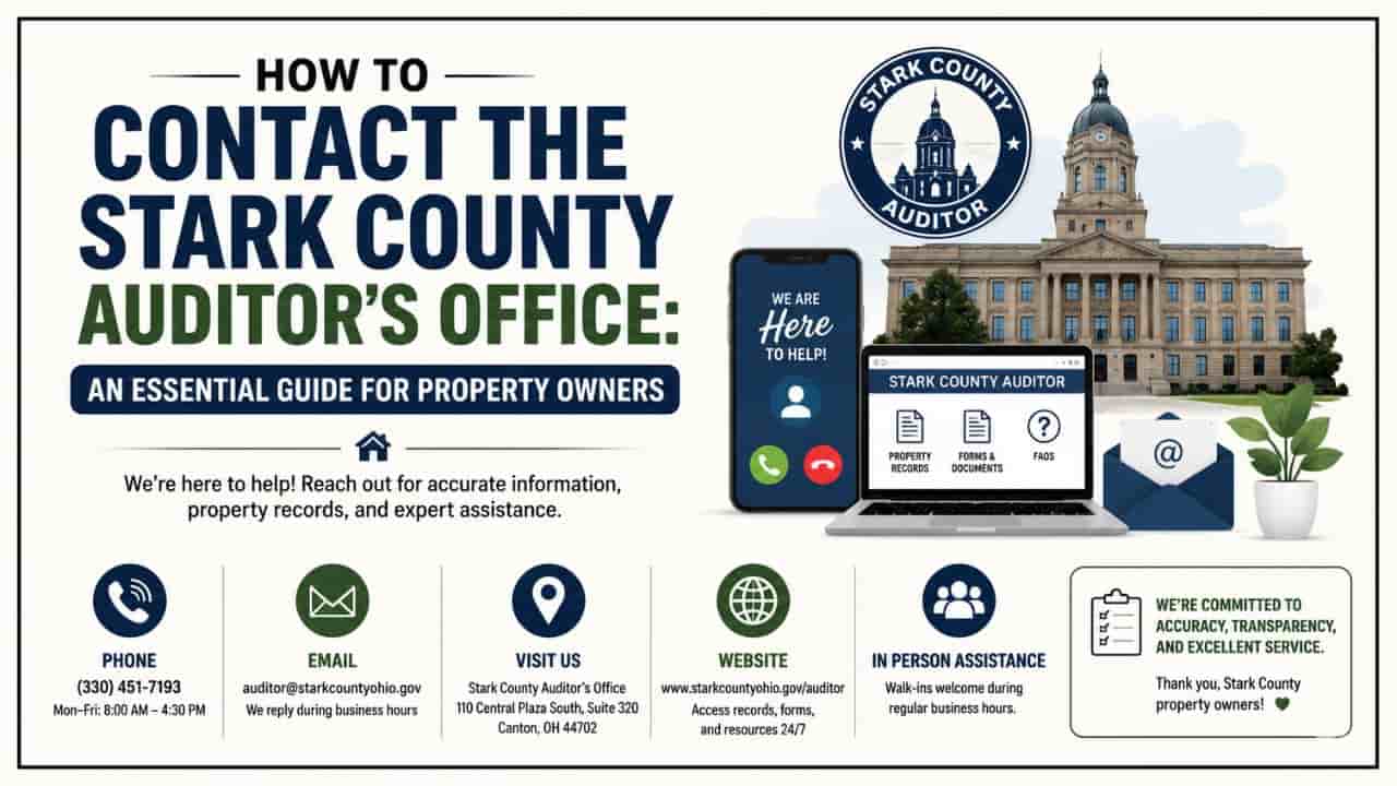
Local Administrative Office Contact Information
If you require certified property abstracts, wish to file a valuation complaint, or need assistance identifying an ambiguous land boundary in Canton, visit the administrative departments directly:
- Stark County Auditor & Map Department: 110 Central Plaza South, Suite 220, Canton, OH 44702
- Stark County Recorder’s Office: 110 Central Plaza South, Suite 200, Canton, OH 44702
Utilizing these official public data channels gives you the accurate, real-time geographic and financial insights needed to successfully understanding the Canton, Ohio real estate market.
Conclusion
Conducting a Canton Ohio property search is a foundational step for anyone navigating the local real estate market. By utilizing the official Stark County Auditor’s Office database, users can seamlessly uncover precise land records, track ownership histories, and evaluate taxable valuations. This public records framework ensures complete financial transparency, helping buyers, sellers, and real estate investors make data-driven decisions while ensuring fair and equitable taxation across all city wards.
FAQs
How do I perform a free property search for a house in Canton, Ohio?
Visit the official Stark County property search portal and input the site address, owner name, or parcel ID to pull up the complete public record immediately.
Where can I find official tax maps for Canton, Ohio parcels?
Tax maps and legal boundary configurations are accessible by opening the interactive Stark County GIS mapping viewer directly from the Auditor’s property data sheet.
Which school district levies affect my Canton property tax rates?
Most properties within city limits are subject to the Canton City School District millage rates, which the Stark County Auditor applies directly to your assessed value.
Why does my Canton property card show two different values?
Ohio law uses a 35% statutory ratio. The appraised value represents 100% market worth, while the assessed value is the 35% baseline used to calculate property taxes.
How long does it take for a new Canton home sale to update online?
It typically takes 5 to 10 business days for the digital database to refresh after a deed is processed by the Auditor’s conveyance department and registered.