Raw land data means nothing without a complete understanding of municipal zoning frameworks. Across Stark County, Ohio, property utility, development potential, and final valuation floors are dictated by overlapping layers of township and municipal codes. Misinterpreting a district boundary or setback constraint can stall a capital project, trigger violation penalties, or render an acquisition completely illiquid. This institutional guide provides a roadmap to auditing Stark County zoning maps, analyzing land-use classifications, and navigating the formal variance process utilizing public records on the Stark County property search portal.
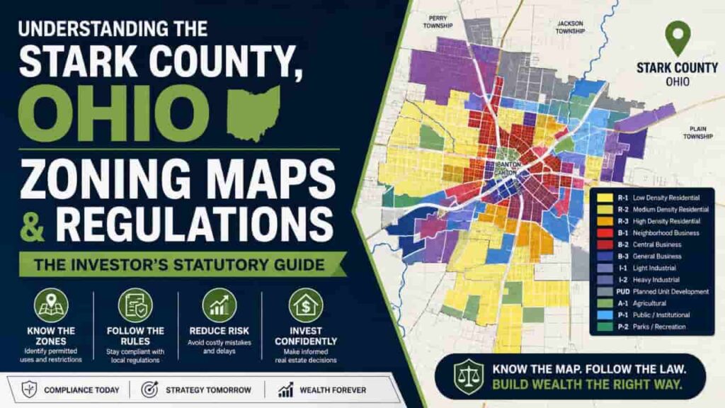
Decoding Stark County Zoning Maps and Jurisdiction Frameworks
A common point of confusion for investors entering the Northeast Ohio market is assuming that a single county entity governs all zoning rules. In reality, Stark County features a decentralized regulatory landscape. While the Stark County Planning Commission provides broad advisory oversight, geographic datasets, and master plan frameworks, actual zoning enforcement falls into two distinct categories:
- Township Resolution Zoning: Unincorporated areas within Stark County’s 17 townships are governed by township trustees and dedicated township zoning inspectors who enforce localized resolutions.
- Incorporated Municipal Codes: Cities such as Canton, North Canton, Massillon, and Alliance maintain autonomous statutory independence, operating under their own tailored city planning commissions and codified ordinances.
Core Land Use Classifications: Boundary Matrix
To assess structural potential, developers must cross-reference official land parcels with the county’s primary spatial classifications. The table below outlines the core parameters, typical regulatory challenges, and strategic utilities for standard Stark County zoning districts.
| Zoning Classification | Core Statutory Scope | Typical Regulatory Constants & Constraints | Strategic Investment Utility |
| Residential (R) | Single-family homes, duplexes, and multi-family high-density structures. | Strict height limits, public right-of-way setbacks, and minimum lot-width dimensions. | Single-family rentals, subdivision engineering, and multi-family infill placement. |
| Commercial (C) | Retail storefronts, professional office centers, and hospitality services. | High floor-area-ratio (FAR) limitations, mandatory parking maximums, and signage code limits. | Suburban retail corridors, commercial developments, and professional office plazas. |
| Industrial (I) | Light manufacturing, logistical warehousing, and processing infrastructure. | Heavy environmental compliance, mandatory noise buffers, and deep property line setbacks. | Distribution hubs, flex-space warehouses, and industrial parks near main transport lines. |
| Agricultural (A) | Farming operations, livestock production, and low-density open acreage. | Minimum multi-acre tract limits, conservation rules, and severe retail business bans. | Strategic long-term land banks, greenfield developments, or agritourism conversion assets. |
Step by Step Guide, Running Digital Zoning Audits
Before finalizing an absolute closing date on a Stark County property, execute this technical layout to audit the parcel’s legal standing:
Step 1: Query the Geographic Information System (GIS) Data Engine
Do not rely on passive marketing claims. Launch the official Stark County GIS Map Portal to pinpoint the asset’s digital footprint.
- Extract the Base Parcel Number: Input the 7-digit identifier into the system to pull the active boundary card.
- Enable Data Overlays: Turn on the zoning layers and administrative boundary lines to identify exactly which township or city holds jurisdiction over the lot.
Step 2: Extract Environmental and Special Overlay Layers
While on the interactive viewer, run an audit for restrictive geographic parameters:
- FEMA Flood Insurance Rate Maps (FIRMs): Check if the lot overlaps a 100-year floodplain, which requires expensive structural engineering and mandatory flood insurance.
- Historic Districts or Design Overlays: Properties sitting in downtown Canton or designated historic preservation zones face strict architectural rules that regulate exterior facade modifications, paint selections, and material use.
Step 3: Compute Spatial Setback and Lot Coverage Ratios
Locate the specific municipal or township zoning text to calculate your true usable footprint. Every structural layout must respect three spatial constants:
Usable Building Area = Gross Parcel Area – Front Yard Setback + Rear Yard Setback + Combined Side Yard Buffers
Additionally, verify the Maximum Lot Coverage Ratio, which restricts the percentage of the raw land that can be covered by impervious surfaces (such as roof footprints, concrete pads, and asphalt parking lots).
Understanding the Variances, Conditional Uses, and Zoning Changes
If a target property is perfect for your portfolio but does not comply with local land-use restrictions, you must navigate the local appeals process. Stark County boards evaluate modifications through three specific legal channels.
- Permitted vs. Conditional Use Authorizations: A permitted use is a structural utility allowed by right (e.g., building a retail store in a commercial zone). A conditional use requires presenting your case before a local Board of Zoning Appeals (BZA) to prove that the business will not negatively impact neighborhood traffic, aesthetics, or public safety.
- Area and Use Variances: If physical site conditions (such as odd topography or narrow lot shapes) make complying with strict setback rules impossible, you can apply for an area variance. A use variance requests permission to operate a business type completely banned by the active zone (e.g., running a commercial business in a residential zone), which carries a much higher burden of proof.
- Comprehensive Zoning Amendments: For large developers planning multi-acre subdivisions or commercial hubs, a full map amendment or rezoning application must be filed, reviewed by the regional planning commission, and approved via a public hearing cycle.
Structural Risk Mitigation for Developers
- Audit Nonconforming “Grandfathered” Assets: If an old building operates outside current zoning rules, verify its legal status. In most Stark County jurisdictions, if a legal nonconforming use is abandoned or sits vacant for more than 12 consecutive months, it loses its protected status and must completely comply with modern codes.
- Coordinate Multi-Jurisdictional Utilities: A parcel may sit within a township’s boundary but require public water and sewer connections from an adjacent city. This often requires entering into an annexation agreement or utility extension contract, which can alter your tax liabilities.
Conclusion
Successfully navigating the Stark County zoning maps and regulations is the ultimate risk-mitigation strategy for real estate investors. By aligning your acquisition pipeline with official land use classifications, analyzing GIS data overlays, and calculating precise building footprint setbacks, you can reliably unlock hidden equity in raw acreage. Avoid regulatory friction by running proactive property audits before closing. Partnering with local township inspectors ensures your development projects remain legally compliant, protected from building code violations, and fully optimized for long-term market appreciation in Northeast Ohio.
FAQs
Where do I access official Stark County zoning maps?
View maps online via the Stark County GIS portal, the planning commission website, or by visiting the specific local municipal or township zoning office holding parcel jurisdiction.
Can township zoning resolutions be overridden by the county?
No. Townships with adopted zoning resolutions hold autonomous enforcement powers. The regional planning commission acts as an advisory body, but final statutory decisions rest with local trustees.
What happens if building plans violate structural setback lines?
You must file an area variance request with the Board of Zoning Appeals (BZA), prove physical property hardships, and secure formal approval during a public hearing.
What is the timeline to complete a commercial rezoning request?
The zoning amendment process typically takes 60 to 90 days, allowing for planning commission reviews, mandatory public notification periods, and final legislative township trustee readings.
How do I verify environmental restrictions or wetland boundaries?
Analyze active federal layers on the Stark County GIS viewer and hire a certified surveyor to complete an official on-site delineation before beginning any property excavation.